
Wood County Neighbor Record Layers
A block lookup joins several public layers. The county map establishes which parcels are near the seed address. CAMA supplies assessor fields for each selected parcel. Deeds explain shared boundaries or easements. Directories and ward records add dated evidence for Parkersburg blocks, while community groups describe civic organization rather than household membership.
| Source | What It Shows About a Block | Access |
|---|---|---|
| Tax-map ArcGIS and CAMA | Parcel geometry, assessor owner and address fields | Free web viewers; confirm source date |
| County deed index | Parties, legal descriptions, plats, easements, shared boundaries | Online index, clerk record room, mail copies |
| Parkersburg directories | Dated street occupants and address conventions | Archives, WVU microfilm, library, 1907 scan |
| Ward and precinct sources | 1910 ward context and current election geography | Archives and county election office; legal limits apply |
| Community groups | Public organization contacts and place-based projects | Public sites; no complete local roster exists |
Owner and occupant are not synonyms. A mailing address may be elsewhere, and a parcel may hold several structures. A map label is not proof of residence. Use the block table to select the right source, then describe the name exactly as that record does: owner, deed party, registered voter, past directory occupant, or organization contact.
Map a Wood County Block
Use the Wood County tax-map viewer to find the seed parcel and visually inspect lots that share a boundary or face the same street segment. The viewer is a JavaScript app, and the research inspection did not expose every live layer, popup field, or date. Copy only information the viewer actually displays, then verify it elsewhere.
- Search or browse to the known address and select its parcel as the starting point.
- List parcel or map IDs for lots sharing a boundary and those fronting the same short street segment.
- Open each parcel in Wood County CAMA. Record owner, situs, mailing address, legal description, and deed book/page as separate fields.
- Use deeds and plats to distinguish a true adjoining tract from an alley, easement, shared lot, or rear parcel.
- Use USPS only to standardize delivery format and ZIP. It cannot identify a person at the address.
This method keeps the search to the immediate block. For a longer run of addresses and their complete property chain, switch to the Wood County street directory. Do not expand a parcel result into an unsupported claim about every person nearby.
Confirm Wood County Neighbor Parcels
CAMA says users may enter any combination of search criteria. Its fields include owner name, parcel address, account number, district, four-part map/parcel, property type, legal description, and deed book/page. A result row is brief: parcel ID, owner, legal description, address, and city. Open the property card before drawing conclusions.
The card separates street address from owner mailing address. It also supplies taxing district, deed reference, sales history, assessment values, class, homestead code, acreage, and dimensions. Those fields describe a parcel and its assessment. A homestead code or matching mailing address may provide context, but neither should be presented as definitive proof that a named person is home now.
The official CAMA form shows the fields used to confirm each parcel around the block.
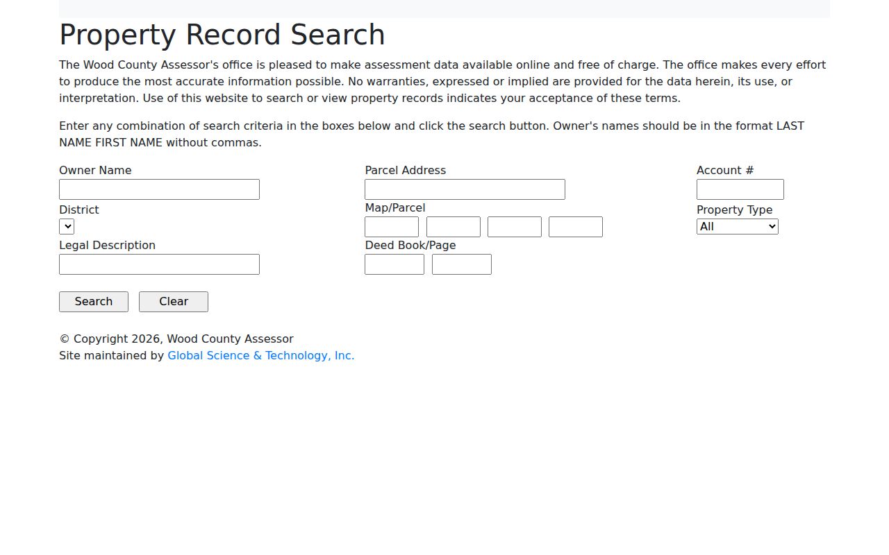
The captured form reinforces the need to search by parcel address or map identifiers, then open and date the selected card.
Wood County Voters by Precinct
The statewide “Am I Registered To Vote” form is an individual status check requiring first name, last name, and date of birth. It returns registration status, party, districts, and polling place, updates nightly, and is not a public block roster. The county clerk provides a separate inspection route under West Virginia law.
Under W.Va. Code §3-2-30, active, inactive, rejected, and canceled files may be examined during clerk hours through printed or read-only access. Printed precinct lists are available for noncommercial use at the statutory one-cent-per-name rate. Public output excludes phone, email, Social Security, and driver-license or nonoperator-ID data.
A voter status is not proof of present occupancy. Returned mail and delayed updates can affect it. Use precinct data for election geography and a narrow record check, never to publish a private block list. The 1910 Parkersburg ward-registration collection is a historical source at the State Archives, not a substitute for the current voter file.
Wood County Community Connections
Community groups form a different layer from official records. The Parkersburg and Wood County Neighborhood Watch Co-op is an umbrella connection for local watch groups chartered by city police and the sheriff. Its public contact channel can connect residents with organized groups, but private social channels and member lists should not be copied.
Neighborhood Watch Co-op
Public umbrella for local watch groups. Use its contact route, not private membership information.
Parkersburg Engagement Project
A civic project with a 2025 baseline survey and public email at info@pkbengagementproject.org.
Wood County Historical Society
Its Resource Barn, cemetery work, maps, photographs, and family files add historical neighborhood context.
The Avery Historic District Community Association appears in a state charity record with an establishment date in 2018 and an expired registration in 2021. That is useful historical evidence of organization, not a current endorsement or resident roster. No complete official list of Wood County associations, HOAs, or block clubs was found.
See Past Wood County Neighbors
Parkersburg directories and Sanborn maps can reconstruct an older block. State Archives directory holdings begin in 1877–78 and continue through 2016 with gaps. The 1907 volume includes corner descriptions, fractions, household marks, occupations, and the letter h for a home address. These conventions help place a name but do not prove ownership.
WVU holds digitized Parkersburg Sanborn maps from 1889 through 1926. Compare neighboring footprints, street names, and uses with the directory street guide and deed legal descriptions. The 1916 Library of Congress set includes North Parkersburg. This map-and-directory pairing is a dated view, not a current neighbor search.
The 1907 directory shows why exact searches fail. Entries may use initials, half-number addresses, “cor” for a corner, or Tavennerville instead of a current city label. Keep the printed form in the notes and test a plain modern spelling separately. Parkwood Library and the Phelps-Tavenner Research Center can help with newspapers, family files, cemetery records, photographs, scrapbooks, and yearbooks when a block cannot be rebuilt online.
Note: Historic maps can show a block before a later street label, but no official Parkersburg renumbering crosswalk was located.
Compare Wood County Neighbor Sources
Official records are narrower than commercial neighbor tools, but their custody and field meaning can be checked. Commercial products may merge old addresses, purchased data, and names without showing when or why a match was made. Do not treat an unverified profile as stronger than a dated county record.
| Source type | Strength | Limit |
|---|---|---|
| County parcel and deed records | Named custodian, parcel and instrument citations | Shows ownership or deed role, not certain occupancy |
| Voter and directory sources | Dated registration or printed address context | Restricted fields, gaps, and possible stale status |
| Commercial neighbor tools | May combine many sources quickly | Methods, dates, and corrections may be unclear |
For a sound block record, preserve the source URL, date checked, exact field label, and the role attached to the name. Confirm important findings with the office or repository that holds the record.
Wood County Block Address Patterns
Address order can reveal a useful map check without identifying a person. Wood County E911 assigns rural addresses by measured drive distance, with even numbers on the right and odd numbers on the left. A shared drive serving enough structures may need a road name and owner agreement. New assignments involve a GPS site visit, so a road label may differ from an old deed or directory form.
Use that parity rule to catch a likely typo, not to invent a missing address. Confirm the assigned address through the Wood County E911 office when a shared drive, mobile home, new structure, or rural road will not line up with the map. Keep the E911 address separate from the deed legal description, assessor situs, owner mailing address, and USPS delivery form.
Older Parkersburg blocks need different checks. A 1907 directory may list a corner, a half-number, or Tavennerville. A Sanborn sheet can show the footprint and neighboring numbers for the period. Compare the historical street sequence to the modern parcel pattern, but do not assume that the same number marks the same lot without deed or plat support.
Protect Wood County Neighbors
Public parcel records do not reveal every renter, household member, phone number, utility account, or delivery detail. Voter files exclude sensitive identifiers. Sealed court files and protected vital records remain unavailable. West Virginia’s Address Confidentiality Program supplies a substitute address and mail forwarding for eligible survivors of domestic violence, sexual assault, stalking, or human trafficking, with four-year enrollment.
Do not try to defeat a protected address or turn a public record into a live-person tracking tool. A responsible neighbor lookup answers a limited property, civic, historical, or personal-safety question. If an owner, address, or status matters, confirm the dated record with its custodian and describe only what it proves.
Lawful use. Use neighbor records for civic curiosity, history, reconnection, and personal safety. Never use them to watch, harass, threaten, or intimidate anyone.