
Walk a Wood County Street
A street search works best as a chain of small checks. Start with the exact number and road name, but keep any apartment, fraction, rural route, or named place in the notes. Wood County systems do not share one address key. The assessor uses a parcel address and map number. A deed may rely on a legal description. E911 assigns a field address, and USPS standardizes a mailing address. A historical directory can preserve wording that has since vanished.
- Enter the property address in the Wood County CAMA search. Save the parcel ID, record owner, situs address, legal description, and deed book and page.
- Open the county tax-map viewer and select nearby parcels one at a time. Confirm each result back in CAMA.
- Use the Wood County document index to follow grantee and grantor names from the current deed into prior transfers.
- For an older Parkersburg address, compare the printed street guide, a Sanborn sheet, and the original deed description. Preserve the source year and exact spelling.
- Finish with the USPS address lookup to confirm today’s delivery form. A postal match does not identify an occupant.
The sequence moves from place to person and back to a dated record. That matters on long rural roads, split parcels, and streets where a mailing city does not match municipal limits. It also prevents an owner name from being presented as proof of residence.
Search Wood County Addresses
The assessor’s CAMA form is the most detailed online starting point for a modern Wood County street directory search. It accepts any combination of fields. The form has no ZIP field, so a street number, owner, account, or parcel identifier is more useful than a postal area. Owner names are entered last name first name, with no comma shown.
| CAMA field | Input | How it helps by address |
|---|---|---|
| Owner Name | Text, last name first | Find parcels tied to a known record owner. |
| Parcel Address | Street text | Find the situs, or physical property address. |
| Account # | Text | Return to a known assessor account. |
| District | Dropdown | Narrow similar road names within Wood County. |
| Map/Parcel | Four short fields | Identify the mapped tract without relying on a street label. |
| Property Type | All, residential, commercial, industrial | Separate unlike parcels on the same road. |
| Legal Description | Text | Match lot or subdivision wording. |
| Deed Book/Page | Two fields | Connect the parcel card to a recorded instrument. |
The live sample card showed why labels matter. Its result row held parcel ID, owner, legal description, address, and city. The full card added a taxing district, mailing address, sales history, assessment history, land measurements, and a deed citation. Those fields describe property and ownership roles, not a list of everyone at the address.
The CAMA interface shown here displays the Wood County property-search fields.
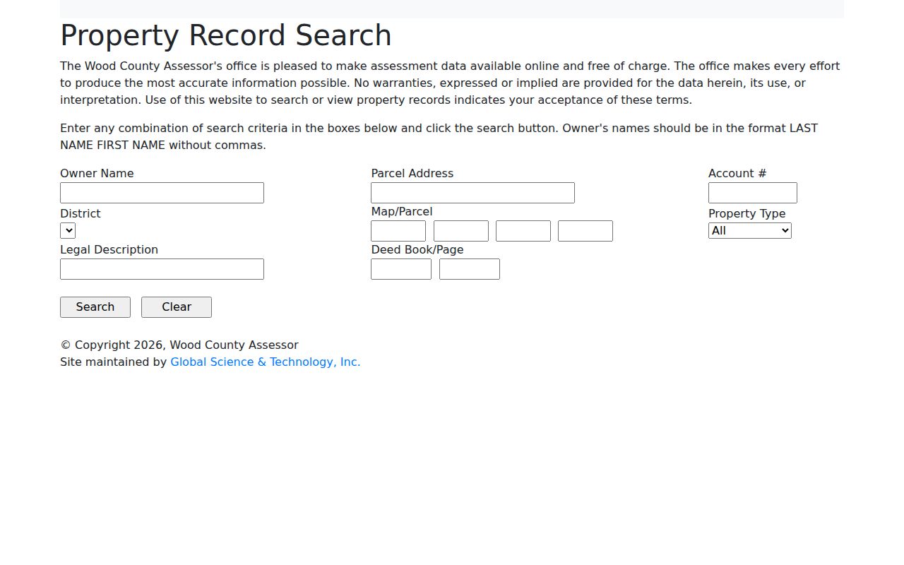
The screen makes the local split plain: parcel address and deed book/page are searchable, while ZIP is not.
Wood County Street Record Layers
No single roll lists every person on a road. A useful Wood County street directory therefore labels each result by source and date. The following records cover different parts of an address trail and have different access channels.
| Address record | Key used | Useful span | Street evidence |
|---|---|---|---|
| CAMA and land books | Parcel address, map/parcel, legal description | Online current scope unstated; land books from 1945 in the record room | Record owner, parcel and assessment context |
| County GIS viewers | Map geometry and displayed address | Current viewer; layer dates not exposed | Street position and adjacent-parcel context |
| County deed index | Grantor, grantee, book/page | Deeds and liens described from 1799 onward | Recorded parties and ownership chain |
| E911 addressing | Assigned road and site address | Current assignment process | Road naming, number parity and shared-drive resolution |
| Parkersburg directories | Printed street or place wording | Holdings from 1877 through 2016, with gaps | Dated household and business leads |
| Sanborn maps | Street, number and footprint | Selected Parkersburg years, 1889 to 1926 | Building existence and use in a map year |
| City permit files | Property address | Request route; no public results search found | Applicant, proposed use and approval context |
| USPS lookup | Mailing address | Current | Standardized delivery address and ZIP, not occupancy |
If an online form fails, use the first-floor County Clerk record room, request copies by mail or in person, ask the library for a narrow microfilm search, or consult the West Virginia State Archives. The clerk does not perform title searches. Researchers must follow the chain themselves.
The physical route also preserves material beyond the web screen. The clerk describes deeds and liens from 1799 to the present, while older land books are held off-site and books from 1945 forward are available through the record room. Ask for the record type, names, date range, and book or page when known. That focused request is more reliable than asking staff to identify everyone connected with a street.
Note: Preserve the query date because parcel cards, mailing addresses, assessments, portal coverage, and GIS displays can change.
Map Wood County Street Parcels
Wood County publishes both a tax-map ArcGIS viewer and a separate address-map viewer. Use the tax map to orient a parcel among its neighbors. Use the address-map viewer when an assigned road address is the stronger lead. Because the JavaScript interfaces did not expose their layer names or identify fields during research, do not assume that a particular popup or export tool is present.
Select one parcel, copy only the fields the viewer actually displays, and verify them through CAMA. Repeat that process parcel by parcel instead of treating proximity as identity. Digital Mapping is listed in courthouse Room 309 at 304-424-1999 when the online map cannot resolve a tract. A rural road may cross parcel formats or districts, so work from a known intersection or address segment.
- Parcel
- A tract identified for mapping and assessment; one parcel may contain more than one structure.
- Situs address
- The physical property address shown by the assessor, which may differ from the owner’s mailing address.
- Plat
- A recorded drawing that lays out lots, boundaries, roads, or easements.
- Criss-cross directory
- A directory section arranged by street and house number rather than by surname.
Chain Wood County Deeds
CAMA’s deed book and page provide a bridge to the County Clerk. In the document index, search the current owner as a grantee, meaning the person or entity receiving an interest. Record the date, document type, book/page, instrument, legal description, and grantor. Then search that grantor as an earlier grantee. A reverse grantor search catches outgoing transfers.
The portal supports date ranges, names, associated names, document categories, subindexes, and document types. Deeds, correction deeds, quitclaim deeds, trustee deeds, tax deeds, plats, easements, rights of way, partitions, probate records, and releases can all change the context of a parcel. An index hit is a pointer. Read the instrument or request a copy before drawing a conclusion.
The Wood County document inquiry shown below is the county’s index route.

Its controls let a street researcher move beyond a single owner name and preserve the book, page, role, and instrument behind each result.
Wood County E911 Address Quirks
Modern numbers may come from the county’s E911 addressing process, not from the old wording in a deed or directory. The office assigns an address after a GPS site visit. Its stated turnaround is three to four working days. Numbers reflect distance along the road, with even numbers on the right and odd numbers on the left. A shared drive serving enough structures may require a road name and an agreement among affected property owners.
That system explains why a valid emergency address, tax situs, mailing line, and legal description may not match word for word. Keep all four forms. Do not overwrite the old string in research notes. When a newly assigned or shared-drive address does not appear in CAMA, use the parcel ID and ask E911 or Digital Mapping to help connect the forms.
Note: No official Parkersburg street-renumbering crosswalk was found, so a claimed old-to-new match needs map, deed, or city-record support.
Repair Parkersburg Street Clues
The 1907 Parkersburg directory shows addresses that resist a modern search box: a corner of Dickel Avenue and Pine, a half-number on Market Street, a home marked with “h,” and the place name Tavennerville. Preserve that print form first. Then locate the street on a Sanborn map, note nearby cross streets, compare the city’s historical assessment or ward material, and test the deed’s legal description.
A Sanborn map supplies a building footprint and period use, not a resident name. The directory supplies a dated household lead, not title. Used together, they can show whether the address existed in that year and whether its printed occupant aligns with another record. The detailed directory holdings and entry conventions belong on the Wood County city directory page.
Can a missing modern number be guessed? No. If plats, maps, directory wording, and city journals do not prove a crosswalk, label the old wording as historical and say the modern match remains unconfirmed.
Request Parkersburg Address Files
Parkersburg permit and zoning records add a city layer to a street directory search. The Building and Code Enforcement page describes permit triggers and application routes, but research found no public result database. Application records can carry the property address, owner, applicant, contractor, current or proposed use, map/parcel, and approval conditions.
Ask the city for a defined address and date range. A written request can use the city’s FOIA channel when the record is not posted. Outside Parkersburg, county records still cover deeds, assessment, GIS, and E911, while Vienna or Williamstown may keep separate municipal files. Their complete permit portals were not verified, so do not treat the Parkersburg route as countywide.
Label Wood County Address Roles
An assessor owner, deed grantee, directory household, voter registrant, permit applicant, and business contact are not interchangeable. The cleanest street-by-street result identifies the record, date, exact address string, person’s stated role, and source. This is especially important when a parcel owner receives mail elsewhere or a building contains several units.
West Virginia voter information also has a separate access rule. The online voter status form requires a known individual’s first name, last name, and date of birth. Office inspection under state law is not a ready-made street export, excludes sensitive fields, and restricts commercial use. Treat it as a lawful confirmation channel, not a public household list.
Wood County Street Directory Limits
A Wood County street directory cannot establish everyone who lives behind a door. CAMA identifies assessment roles. Deeds record interests in land. GIS shows place. USPS validates delivery formatting. Historical directories are snapshots with gaps, and permit records may name an applicant rather than an occupant. Even two records that agree may reflect the same old source.
Use the result for family history, property curiosity, estate research, fraud avoidance, or civic transparency. Confirm any claim with the office that keeps the record. The Wood County Clerk record room, the assessor, E911, Parkwood Library, and State Archives remain vital when a portal is incomplete.
Lawful use. Public address records are for lawful research. Never use them to stalk, harass, intimidate, or expose a protected address.